
Belgrade From the Water: Complete Guide to the City’s River Views

Belgrade makes more sense from the water.
From its streets, the city can feel like a collection of separate worlds: a fortress above the old centre, wide modern blocks across the Sava, the church towers of Zemun, new glass towers, working riverbanks, bridges and unexpectedly wild islands. From river level, those fragments enter the same view.
You can see why Belgrade Fortress occupies the high ground above the confluence. You can understand how Old Belgrade, New Belgrade and Zemun relate to one another. You can watch the compact historic skyline give way to the open scale of the postwar city-and then disappear behind the trees of Great War Island.
This guide is not another list of Belgrade attractions or a guide to choosing a boat tour. It is a field guide to what the city reveals from the Sava and Danube: its geography, architecture, history and changing relationship with the rivers.
If you first need an introduction to the waterways themselves, read our complete guide to the Sava and Danube rivers in Belgrade. If you are deciding when to go, what type of boat to choose or what to expect on board, use our guide to Belgrade river cruises.
Belgrade From the Water at a Glance
View | What it reveals |
Belgrade Fortress | Why the historic city developed above the confluence |
Old Belgrade riverfront | The compact, elevated form of the old city |
New Belgrade | The scale and horizontal logic of the postwar city |
Zemun | A historic riverside town with a story distinct from central Belgrade |
Great War Island | Protected nature occupying the geographical centre of the capital |
Sava bridges | The connections between old Belgrade and the city’s modern expansion |
Belgrade Waterfront | The latest major transformation of the Sava bank |
First, Understand the Geography
Belgrade stands at the point where the Sava flows into the Danube. The confluence is below Belgrade Fortress, beside Ušće and Great War Island.

The easiest way to orient yourself is to think of three urban landscapes:
Old Belgrade rises east and southeast of the Sava, with the fortress and historic centre occupying higher ground.
New Belgrade spreads across the flat western bank of the Sava.
Zemun directly adjoins New Belgrade to the northwest and faces the Danube and Great War Island.
Zemun and New Belgrade are therefore on the same general side of the rivers. They are neighbouring parts of contemporary Belgrade, although they developed at different times and still have very different architectural identities.
Great War Island sits at the confluence, between the urban shores. Across the Danube, beyond the island and the main channel, lie the low northern settlements of Krnjača, Borča and Ovča.
This geography explains why one turn on the river can transform the view. Old Belgrade may be rising behind you, Zemun opening ahead and New Belgrade stretching along your side-all while the island blocks parts of each skyline with dense greenery.
Why Belgrade Looks Different From River Level
Seeing Belgrade from a boat is not simply the street view with more water in front of it. Distance and movement change the way the city can be read.

The city’s elevation becomes visible
On foot, you experience Belgrade’s hills as slopes, steps and tiring streets. From the Sava, the height of the old city becomes a single composition. The fortress ridge, Kalemegdan, the Victor Monument and the buildings above the river appear in vertical layers.
This makes the old city’s defensive position immediately understandable. The fortress was not placed beside the rivers; it was placed above them, where movement across the plains and along both waterways could be observed.
Neighbourhoods become skylines
Inside Zemun, you notice lanes, façades and the climb toward Gardoš. From the Danube, those details form a recognisable riverside silhouette. Inside New Belgrade, the distance between buildings can make individual blocks difficult to understand. From farther away, towers, lower housing, green space and the riverbank become part of one large urban plan.
The bridges create visual chapters
From land, bridges are usually infrastructure: a way to cross the river or a source of traffic. From the water, they become gateways. Passing beneath one closes the view behind you and opens a different section of the city ahead.
Natural and urban Belgrade occupy the same frame
Perhaps the greatest surprise is how quickly the city disappears. A fortress, tower or apartment block may dominate one direction while the opposite bank is filled with reeds, trees, birds and quiet channels.
Belgrade’s river view is not one continuous postcard skyline. Its interest comes from interruption and contrast.
The View That Explains Belgrade: Fortress, Confluence and Great War Island
If one river view can be said to explain Belgrade, it is the space around the confluence.
Above the water stands Belgrade Fortress, constructed and altered across many centuries because this high position controlled access to both rivers. The Victor Monument marks the edge of the ridge, while the lower fortress and Nebojša Tower bring the fortifications closer to river level.
Below, the Sava completes its journey and joins the Danube. The physical widening is usually easier to recognise than a perfectly sharp line between two differently coloured rivers. Water colour and the visibility of the currents change with rainfall, sediment, season and light.
Great War Island occupies the space in front of the urban shores. Instead of a monumental building at the centre of the capital’s geography, Belgrade has a protected river island. Its vegetation blocks and reveals the city as you move, making the skyline feel less fixed.
Around this one area, several versions of Belgrade face one another:
the fortress and historic centre on higher ground;
New Belgrade on the flat Sava bank;
Zemun along the Danube;
the low landscape beyond the Danube;
Great War Island between them.
Kalemegdan gives you the classic view from above. A boat reverses it. From the water, you see the height that the fortress commands and move through the geography that the viewpoint overlooks.
Old Belgrade: A City Rising Above the Sava
Old Belgrade presents its strongest river silhouette along the Sava.
The fortress is the dominant feature, but the view continues south through the old riverside and the elevated neighbourhoods above it. The Cathedral Church area and Kosančićev Venac belong to the historic ridge, while Beton Hala occupies the lower bank below.
From river level, the separation between upper and lower Belgrade is easy to see. The city did not develop as one gentle promenade descending toward the water. Defensive ground, port activity, railway infrastructure, roads and repeated reconstruction all shaped the bank.
That history is one reason central Belgrade can sometimes feel disconnected from its rivers even when they are geographically close. A place may be only a short distance from the Sava on a map but separated from it by a steep descent, a major road or infrastructure.
The river also changes the apparent scale of familiar landmarks. The Victor Monument is not a huge object when seen nearby in Kalemegdan, but from the water its exposed position makes it a clear point on the skyline. Nebojša Tower, by contrast, feels more connected to the working level of the river and the lower fortress.
What the Sava gives you is not a perfect view of every historic building. It gives you something more useful: the shape of the old city and the reason it occupies that shape.
New Belgrade: The Horizontal City
Turn toward New Belgrade and the composition changes.
The old city is elevated, visually dense and irregular. New Belgrade is flatter, more open and more horizontal. Its identity comes from the relationship between buildings, roads and green space rather than from one continuous historic street wall.
The municipality was developed most intensively after the Second World War as a major expansion of the Yugoslav capital. Administrative buildings, cultural venues, housing blocks, parks and broad transport corridors were planned across terrain west of the Sava.
From inside an individual block, this scale can be difficult to grasp. Trees and large distances interrupt the sight lines, while towers may appear as isolated objects. From the river, repeated forms and wider relationships become clearer.
Depending on the route and vegetation, the New Belgrade panorama can include the Ušće area, sections of the river promenade, residential towers and glimpses toward major modernist buildings. What matters is not whether every landmark appears unobstructed. The view reveals the underlying contrast: New Belgrade occupies the plain, while Old Belgrade rises across the Sava.
The riverfront also shows that New Belgrade is not a single architectural moment. Socialist-era planning, later commercial development, riverside recreation and contemporary construction coexist along the same bank.
For a closer look at the blocks, public buildings and urban planning, continue with our forthcoming New Belgrade Travel Guide: Architecture, History and Things to Do.
Zemun: Belgrade’s Other Historic Skyline
Zemun is part of Belgrade today, but its river view preserves the feeling of a town with its own centre and history.
Its old streets rise from the Danube toward Gardoš Hill. Church towers, tiled roofs and the Millennium Tower create a more intimate silhouette than the monumental ridge of Old Belgrade or the open scale of New Belgrade.
The difference is historical as well as visual. Zemun developed separately from Belgrade for centuries and spent important periods within the Habsburg world, across the rivers from Ottoman Belgrade. It became part of the administrative city of Belgrade in 1934, long before the postwar construction of New Belgrade filled much of the space between the historic urban areas.
Today, Zemun and New Belgrade meet on the same side of the rivers. There is no river separating them. Moving along the Danube reveals a transition between two adjoining districts whose architecture tells very different urban stories.
From land, Gardoš offers an elevated view over the Danube and rooftops. From the river, the direction is reversed: the hill, tower and old town become the subject of the panorama.
Our local guide to the best things to do in Zemun explains how to explore its streets, market, Gardoš and quay on foot.
The Islands: Where the City Disappears
Belgrade’s islands interrupt the assumption that the centre of a European capital should be completely urbanised.
Great War Island is the most important example. From a high viewpoint, it resembles a green shield in front of the confluence. From river level, it becomes a landscape with edges, channels, changing vegetation and visible distance between its shores.
As a boat moves past the island, the city repeatedly disappears behind trees and reappears through openings. The fortress may vanish. Zemun may come into view. The wide Danube may briefly feel far removed from a capital city.
The island is protected and ecologically sensitive. It should not be treated as an ordinary urban park with unrestricted access. Lido Beach on the Zemun side is associated with seasonal summer recreation, while access arrangements and conditions can change.
Small War Island lies nearby and contributes to the same river landscape. Farther along the Sava, islands and former islands such as Ada Ciganlija and Ada Međica show other relationships between recreation, settlement and nature.
Read our complete guide to Great War Island for its history, natural significance, Lido Beach and current visitor considerations.
Belgrade’s Bridges as Chapters in the View
Belgrade’s bridges are among the clearest markers of movement along the Sava.
Branko’s Bridge: the central connection
Branko’s Bridge connects the historic centre with New Belgrade. From below, its span frames the contrast between the older city and the flat modern bank. It also marks the movement from the confluence area into the more enclosed central Sava corridor.
Gazela: the infrastructure of the working city
Around Gazela, the river view becomes less ceremonial. Roads, railway structures and large transport systems reveal Belgrade as a working regional capital rather than a sequence of visitor attractions.
Railway bridges: older and newer transport layers
The railway bridges add another scale to the Sava landscape. Their structures are best understood from a distance and from below, where the relationship between the river and Belgrade’s transport development becomes visible.
Ada Bridge: the contemporary landmark
Ada Bridge is recognisable by its tall pylon and cable-stayed form. It changes the southern Sava skyline and signals the transition toward Ada Ciganlija and the wider recreational river landscape.
The view around Belgrade’s bridges is currently evolving. Construction of a replacement crossing on the site of the former Old Sava Bridge is changing the central river scene, so photographs and route descriptions from earlier years may no longer match what visitors see.
The Changing Sava Skyline
The Sava bank shows Belgrade’s urban transformation more clearly than almost any other part of the river journey.
Near the old centre, the historic ridge remains above the river. Closer to Branko’s Bridge and farther south, transport infrastructure, former industrial and railway land, promenades and new development appear in quick succession.
Belgrade Waterfront has introduced a new vertical skyline along land once associated heavily with railway use. Its towers, landscaped promenade and commercial spaces represent a very different relationship with the river from the fortress, port, railway or informal floating venues.
From street level, the development is experienced through individual buildings and public spaces. From the Sava, it appears as one large intervention in the city’s silhouette.
The river view does not require you to treat that change as either the whole future of Belgrade or a simple success story. It allows you to compare it with the historical ridge above, New Belgrade across the water and the remaining infrastructure beside it.
This is one of the strengths of seeing the city from a moving boat: no single development can control the entire frame for long.
The Danube Side: A Wider, Wilder Belgrade
The Sava often feels architectural and enclosed by the city. The Danube feels wider and more open.
Along the Danube side, the view can include Zemun, Great War Island, the lower edge of Dorćol, the Port of Belgrade, marinas, floating structures and low northern riverbanks. The scale of the water becomes a subject in itself.
The Danube also places Belgrade within a much larger geography. It continues east through Serbia toward the Black Sea and forms part of an international river system connecting cities and regions far beyond the capital.
That larger scale affects the atmosphere. The Sava journey often feels like moving through central Belgrade. On the Danube, the city can seem to loosen around the edges. Islands, working banks and broad distances become as important as monuments.
What Can You See Best From the Water?
Some Belgrade landmarks can be visited properly only on land. A boat will not show you the interior of the fortress or the streets behind Zemun’s riverfront. What it provides is relationship and scale.
The views that become clearest from the water include:
the full height of the fortress ridge, from the river to the monuments above;
the relationship between Old Belgrade, New Belgrade and Zemun, which are difficult to hold in one mental map while moving through the streets;
the edges and channels of Great War Island, rather than only its upper surface from a viewpoint;
the scale and underside of the bridges;
the continuous New Belgrade riverfront, seen across a wider distance;
the contrast between landscaped, working and natural banks;
the speed with which dense city gives way to vegetation and open water;
the layers of the Sava skyline, from historic heights to transport infrastructure and contemporary towers.
The river does not replace exploring Belgrade on foot. It gives you the orientation that makes those later walks easier to understand.
How Belgrade’s River Views Change During the Day
There is no universally perfect hour. The best time depends on whether you want detail, photography or atmosphere.
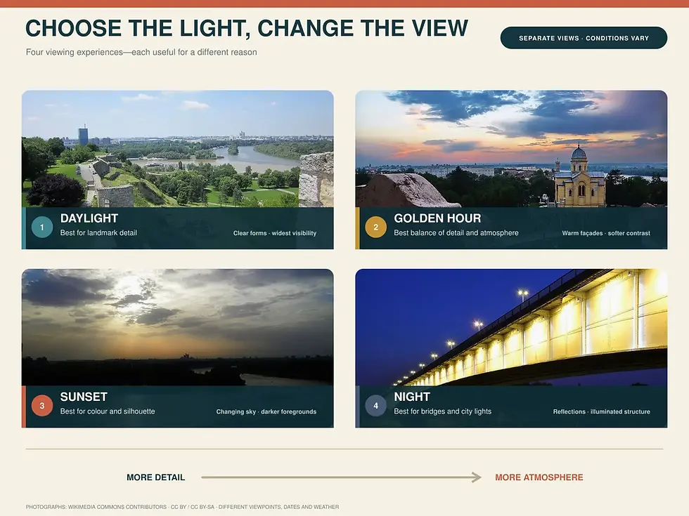
Morning: quiet water and clearer observation
Morning can offer calmer surroundings and comfortable temperatures, especially in summer. It is well suited to watching river activity, wildlife and architectural details without the emotional emphasis of sunset.
Afternoon: strong visibility
Daylight makes it easier to identify buildings, bridge structures and the differences between the urban banks. In the hottest part of summer, however, direct sun and high temperatures can make midday less comfortable.
Golden hour: the most balanced view
Before sunset, warmer light gives façades, concrete and vegetation more depth. Long shadows help define the height of Old Belgrade and the forms of New Belgrade. This is often the best compromise between clear sightseeing and atmosphere.
Sunset: colour, silhouettes and movement
At sunset, the city becomes less about identifying every detail and more about the relationship between water, light and skyline. Exact conditions vary with cloud cover, season and the direction of the route, so no operator can guarantee one fixed sunset image.
After dark: bridges and modern skylines
At night, illuminated bridges and contemporary buildings dominate. Great War Island and quieter riverbanks recede into darkness, while many historic details become difficult to recognise. A night journey can be atmospheric, but daylight or golden hour is better for understanding the city.
Best Places to See Belgrade’s River Landscape From Land
You do not need to board a boat to enjoy Belgrade’s rivers. Several land viewpoints reveal important parts of the landscape.
Kalemegdan and the Victor Monument
This is the essential high viewpoint over the confluence, Great War Island, New Belgrade and Zemun. It is best for understanding the broad geography before seeing it from river level.
Ušće
The park and riverbanks around Ušće place you close to the meeting of the rivers. The terrain is flat, and the fortress appears across the water rather than below you.
Zemun Quay
The quay is ideal for a long, easy Danube walk and close views toward Great War Island. It combines river scenery with cafés, restaurants and everyday neighbourhood life.
Gardoš
Gardoš gives you an elevated view over Zemun, its rooftops and the Danube. It explains Zemun’s local geography better than the broader layout of the entire confluence.
Sava Promenada
This landscaped central promenade provides direct access to the newer Sava riverfront, modern towers and several bridges.
Dorćol riverfront
The lower Danube bank near Dorćol shows a less polished mixture of recreation, river activity and working waterfront. It is useful for understanding the river as part of everyday Belgrade.
Ada Ciganlija
Ada is the place to experience Belgrade’s recreational relationship with water: walking, cycling, sport, cafés and summer swimming in Sava Lake. It is not the best place for the historic skyline, but it reveals how residents actually spend time beside the water.
From Above, From the Bank or From the Water?
Perspective | Best for | Main limitation |
Kalemegdan | Confluence and broad geographic orientation | You observe the rivers rather than move through them |
Riverbank | Everyday atmosphere, walking and local life | You normally see only one section or the opposite bank |
Bridge | Elevated urban and architectural views | Noise, traffic and limited places to stop safely |
Boat | Continuous geography, scale and changing skylines | What is visible depends on the route, daylight and conditions |
The perspectives work best together. See the confluence from Kalemegdan, walk beside one of the rivers and then move between the banks on the water. Each experience corrects what the others leave out.

A Visual Journey Through Belgrade’s Urban History
A central river journey can be read as a sequence of seven urban landscapes:
Belgrade Fortress and the historic ridge: the strategic city above the confluence.
The lower old riverfront: defensive structures, port activity and the divide between upper and lower Belgrade.
Zemun: a historic Danube town shaped by a different political and cultural history.
Great War Island: protected nature surviving between major urban districts.
New Belgrade: the postwar expansion of the Yugoslav capital across the plain.
The bridge and railway corridor: the infrastructure that tied the expanding city together.
The contemporary Sava skyline: new promenades and towers continuing to reshape the riverbank.
This is why Belgrade from the water is more than a panorama. Roman and medieval fortifications, Ottoman and Habsburg frontiers, nineteenth- and twentieth-century infrastructure, socialist planning, protected nature and contemporary development can enter the same journey.
How to Experience Belgrade From the Water
A route that includes parts of both the Sava and Danube provides the broadest introduction. The Sava gives you the strongest architectural contrast between Old and New Belgrade, central bridges and the changing waterfront. The Danube opens toward Zemun, Great War Island and a wider natural landscape.
Routes vary according to the departure point, duration, river conditions, navigation requirements and the type of experience. Not every cruise travels beneath every bridge or passes every landmark. Visibility also changes with vegetation, weather, water level and daylight.
For first-time visitors interested in the city rather than only the atmosphere, a guided sightseeing route during daylight or golden hour provides the most context. A sunset journey places greater emphasis on colour, breeze and skyline.
Belgrade Turtle Cruise’s regular sightseeing experience lasts approximately 90 minutes and is designed to show the relationship between the city, the Sava and the Danube.
Current departure dates, times and inclusions should always be checked on the booking page because the public schedule changes seasonally.
For practical help, including timing, weather, clothing, children, accessibility and choosing a cruise, read the complete Belgrade river-cruise guide.
Belgrade Is Not Simply a City With Two Rivers
Belgrade’s rivers do more than provide a backdrop.
They explain why the fortress stands where it does, why Old Belgrade rises while New Belgrade spreads across the plain, why Zemun maintains a separate identity and why a protected island can occupy the centre of a major capital.
Walking introduces you to Belgrade’s neighbourhoods. Looking from Kalemegdan reveals its geography from above. Seeing it from the water connects those experiences into one moving landscape.
That is the real value of Belgrade’s river views. They do not simply make the city look beautiful. They make its shape, and many of its contradictions, easier to understand.
Frequently Asked Questions About Belgrade From the Water
What can you see from a boat in Belgrade?
Depending on the route, you may see Belgrade Fortress, the Victor Monument, Nebojša Tower, the Sava–Danube confluence, Great War Island, Zemun, New Belgrade, central Sava bridges and the modern Belgrade Waterfront skyline. Not every route includes every landmark.
What are the best river views in Belgrade?
The defining views include Belgrade Fortress above the confluence, Great War Island between the urban shores, Zemun beneath Gardoš, the contrast between Old and New Belgrade and the central Sava skyline framed by its bridges.
Can you see Belgrade Fortress from the river?
Yes. The fortress is one of the clearest landmarks from the Sava and the confluence. River level reveals the height of the fortress ridge more clearly than the view from the surrounding streets.
Can you see both the Sava and Danube on one cruise?
Yes, some central sightseeing routes include sections of both rivers and pass through or near their confluence. Check the stated route before booking because itineraries vary.
Where is the best view of the Sava and Danube confluence?
Kalemegdan offers the classic panoramic view from above. Ušće provides a lower land-based perspective, while a boat allows you to move through the confluence and see how the surrounding districts relate to it.
Is Belgrade better from the river during the day or at sunset?
Daylight is better for identifying architecture, geography and landmarks. Golden hour and sunset are better for atmosphere, warm light and silhouettes. The best choice depends on whether sightseeing or mood matters more to you.
Can you see Zemun from central Belgrade?
Yes. Zemun can be seen across the Danube and beyond Great War Island from several central viewpoints, particularly Kalemegdan. From a boat, its quay, old town and Gardoš skyline become more distinct as you approach.
What is the island between Belgrade and Zemun?
Great War Island is the large protected river island at the confluence between the historic centre, New Belgrade and Zemun. Small War Island lies nearby.
Can you see New Belgrade from the river?
Yes. New Belgrade occupies the flat western bank of the Sava and continues toward Zemun along the Danube side. From the water, its open planning and horizontal scale contrast clearly with elevated Old Belgrade.
Where can you see Belgrade’s skyline without taking a boat?
Good land-based viewpoints include Kalemegdan, Ušće, Zemun Quay, Gardoš, Sava Promenada and parts of the Dorćol riverfront. Each shows only part of the river landscape, so combining two viewpoints gives a better orientation.


Comments